

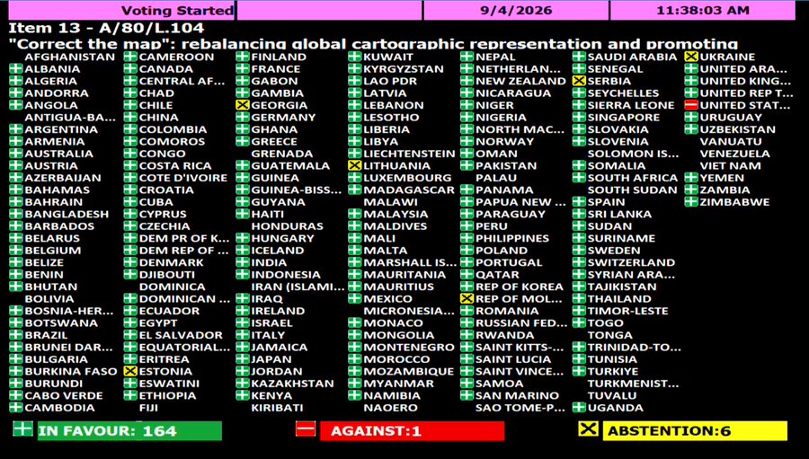
Georgia, alongside Estonia, Lithuania, Moldova, Serbia, and Ukraine, was among the six countries that abstained in the September 4 vote on a U.N. General Assembly resolution aimed at more accurately reflecting the sizes of continents on the world map, following an African-led “Correct the Map” campaign against the dominant Mercator projection distorting perceptions of Africa’s true size.
The non-binding resolution, offering an alternative “Equal Earth” projection for a fairer representation, was adopted with 164 votes, with the United States being the only country that voted against, after dismissing the initiative as part of a “radical ideological project,” according to the UN press release. Countries like the United Kingdom, France, Germany, as well as China and Russia, voted in favor.
Georgian officials are yet to comment on the reasons for the abstention. However, Ukrainian abstention is reportedly linked to the controversial depiction of Crimea and other Russian-occupied Ukrainian territories in different “Equal Earth” maps. According to the Equal Earth campaign website, “Russian occupied Crimea is shown in neutral gray.”
Reacting to the vote and the supportive statement of the Russian representative, the Ukrainian representative raised concerns about Russian attempts to legitimize the illegal occupation of Crimea, calling on the UN member states”to be vigilant and proceed carefully with such documents that were adopted today” and “to be aware of the dangers of that Pandora box that you have opened today.”
According to the Ukrainian explanation published on September 4, while Kyiv “does not in principle oppose to the core issue addressed” in the draft resolution, the “Equal Earth” maps “depict parts of Ukraine’s territory that have been temporarily occupied by Russia … in a manner that is wholly unacceptable.”
The African-led “Correct the Map” campaign is a reaction to the widespread use of the world map based on the Mercator projection, devised by Flemish cartographer Gerardus Mercator in the 16th century to address a practical problem in maritime navigation: on his projection, straight lines correspond to constant compass directions.
“But preserving direction came at the expense of area,” according to the U.N., resulting in distortions such as Greenland appearing comparable in size to Africa, despite being 14 times smaller. The campaign advocates wider use of the “Equal Earth” projection, which more accurately represents the relative sizes of continents.
Robert Dussey, foreign minister of Togo, a country that led the negotiations in the campaign backed by the African Union, was cited as saying before the vote that “maps shape our understanding of the world” and “they guide education, nourish the imagination, and influence collective perceptions.”
“For over 450 years, we have based our understanding of Africa, and the world, on a map that is wrong!” a statement on the website of the Correct the Map campaign reads. “In fact, you could fit the United States, China, India, Japan, Mexico and much of Europe into Africa and still have land to spare. The Mercator map isn’t just about misrepresenting the size of the global South — it’s about power and perception.”
Also Read:

